Geography · Colouring and labelling worksheet
Map of the UK: Free KS2 Geography Worksheet on the Four Nations and Capitals
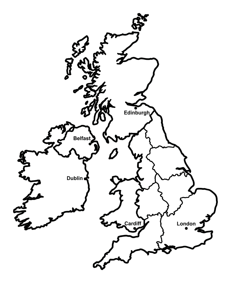
This free, printable worksheet helps children aged 9 to 11 name and locate the four nations of the United Kingdom and their capital cities on a blank outline map: England (London), Scotland (Edinburgh), Wales (Cardiff) and Northern Ireland (Belfast). Children colour each nation a different colour, then label the nations and capitals using the word bank.\n\nIt is completely free to print, use and share, at home or in the classroom. Just press print, or save it as a PDF.

Map of the United Kingdom
Free Geography worksheet · Ages 9 to 11
Colour the four nations
Colour each of the four nations of the United Kingdom a different colour so you can tell them apart. Leave the sea around the outside white, or colour it blue if you like. The Republic of Ireland is shown for context, you can leave it uncoloured.
- Colour England, Scotland, Wales and Northern Ireland each a different colour.
Label the nations and capitals
Look at the map and the dots marking the capital cities. Write the name of each nation and its capital city on the lines, using the word bank to help you.
The largest nation, in the south and east of Great Britain, and its capital
The nation in the north of Great Britain, and its capital
The nation to the west of England, and its capital
The nation in the north-east of the island of Ireland, and its capital
Answer key
- The largest nation, in the south and east of Great Britain, and its capital — England — London
- The nation in the north of Great Britain, and its capital — Scotland — Edinburgh
- The nation to the west of England, and its capital — Wales — Cardiff
- The nation in the north-east of the island of Ireland, and its capital — Northern Ireland — Belfast
What is on the worksheet
One clear outline map of the United Kingdom, with the internal borders between England, Scotland, Wales and Northern Ireland drawn in so each nation forms a separate region. A small dot marks roughly where each capital city sits, and the island of Ireland is shown so children can see that Northern Ireland shares it with the Republic of Ireland. A word bank lists the four nations and four capitals, and there are write-on lines for the answers.
The map has bold, even outlines and is sized for older primary children, with regions large enough to colour neatly and to write small labels alongside. Because the boundaries are already drawn, pupils can focus on recall and location rather than freehand map-drawing.
How to use it at home or in the classroom
Print the worksheet, or open it on a tablet and print from there. Begin by colouring each of the four nations a different colour; this makes the separate regions easy to read at a glance and is a relaxed way in to the task.
Then work through the labelling. Children locate each nation and its capital dot, then write the names on the lines using the word bank for support. To stretch upper-KS2 pupils, ask them to cover the word bank and recall the answers from memory, or to add the surrounding seas (the North Sea, Irish Sea, English Channel and Atlantic Ocean) and a few major cities or rivers. It pairs well with an atlas, a wall map or an online map for checking.
What your child will learn
By the end of the activity, your child should be able to name and locate the four nations of the United Kingdom and match each to its capital city: London is the capital of England, Edinburgh of Scotland, Cardiff of Wales and Belfast of Northern Ireland.
They will also firm up the distinction between the United Kingdom, Great Britain and the British Isles, and understand that the UK is a single sovereign state made up of four nations. Secure knowledge of the UK map underpins the wider KS2 locational work on counties, cities, regions and the physical and human characteristics of places.
A note for teachers
This worksheet supports the Key Stage 2 geography programme of study for locational knowledge, which asks pupils to name and locate counties and cities of the United Kingdom, its geographical regions and their identifying human and physical characteristics. Naming the four nations and capitals on a blank map is a foundational recall task that sits beneath that wider objective and is a useful starting point or recap before studying regions and counties in more depth.
A point worth clarifying with pupils: the United Kingdom comprises England, Scotland, Wales and Northern Ireland; Great Britain is the largest island, holding only England, Scotland and Wales; and the British Isles is the wider archipelago, including the whole island of Ireland. The map shows the Republic of Ireland for context, but it is a separate country and not part of the UK. There is no log-in, no watermark and no catch; you are welcome to print copies for your class and to link to this page from your school website or newsletter.
Frequently asked questions
What are the four nations of the UK and their capital cities?
The four nations are England, with its capital London; Scotland, with its capital Edinburgh; Wales, with its capital Cardiff; and Northern Ireland, with its capital Belfast. Together they form the United Kingdom of Great Britain and Northern Ireland.
What is the difference between the UK, Great Britain and the British Isles?
The United Kingdom is the country made up of England, Scotland, Wales and Northern Ireland. Great Britain is the largest island and holds only England, Scotland and Wales. The British Isles is the wider group of islands, including the whole island of Ireland and many smaller islands. The Republic of Ireland sits in the British Isles but is a separate country, not part of the UK.
What age or year group is this worksheet for?
It is designed for children aged 9 to 11, which is Years 5 and 6 (upper Key Stage 2) in England. Confident Year 4 pupils and anyone revising UK geography will find it useful too, and the word bank can be removed to make it more challenging.
Is this UK map worksheet free to print and share?
Yes. It is completely free to print, use at home or in class, and share. There is no sign-up and no watermark. You are welcome to link to this page from a school website or newsletter.
How do I print or save the worksheet?
Press the Print button on this page, or use your browser's print option. To keep a copy, choose 'Save as PDF' as the destination in the print dialog. The worksheet is designed to fit a single A4 page.
Curriculum links
- KS2 Geography Locational knowledge (statutory): 'name and locate counties and cities of the United Kingdom, geographical regions and their identifying human and physical characteristics, key topographical features (including hills, mountains, coasts and rivers), and land-use patterns; and understand how some of these aspects have changed over time'
- KS2 Geography Geographical skills and fieldwork (statutory): 'use maps, atlases, globes and digital/computer mapping to locate countries and describe features studied'
- KS2 Geography Geographical skills and fieldwork (statutory): 'use the eight points of a compass... and four-figure grid references... to build their knowledge of the United Kingdom and the wider world'
Made by The Owee education team. Updated 02/06/2026. Free to print and share.
More learning, made playful
Owee turns topics like this into age-right quizzes for children aged 5 to 10, with a treehouse that grows as they learn. Three subjects are free, forever.
Get Owee free