Geography · Colouring and labelling worksheet
Countries and Capitals of the UK: Free KS1 Geography Worksheet
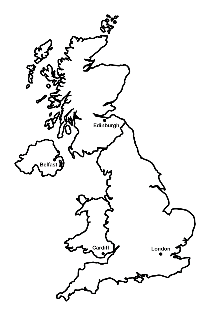
This free, printable worksheet helps children aged 5 to 7 learn the four countries of the United Kingdom and their capital cities: England (London), Scotland (Edinburgh), Wales (Cardiff) and Northern Ireland (Belfast). Children colour each country a different colour on a simple map, then name the countries and write their capital cities using the word bank.
It is completely free to print, use and share, at home or in the classroom. Just hit print, or save it as a PDF.

Countries and Capitals of the UK
Free Geography worksheet · Ages 5 to 7
Colour the map
Colour each of the four countries of the United Kingdom a different colour. Leave the sea around the outside white, or colour it blue if you like.
- Colour England, Scotland, Wales and Northern Ireland each a different colour.
Name the countries and capitals
Look at the map. Write the name of each country, then write its capital city next to it. Use the word bank to help you.
The largest country in the south, and its capital city
The country in the north, and its capital city
The country to the west of England, and its capital city
The part of the UK on the island of Ireland, and its capital city
Answer key
- The largest country in the south, and its capital city — England — London
- The country in the north, and its capital city — Scotland — Edinburgh
- The country to the west of England, and its capital city — Wales — Cardiff
- The part of the UK on the island of Ireland, and its capital city — Northern Ireland — Belfast
What is on the worksheet
One clear, friendly outline map of the United Kingdom, with the four countries shown as separate regions divided by bold lines. A small dot marks roughly where each capital city sits. There is a word bank to support early readers, and write-on lines for the four country names and their four capital cities.
The map has bold, even outlines and plenty of open sea around it, so it is comfortable for small hands to colour and a pleasure to display afterwards. Children can give each country its own colour, which also helps them see that the UK is made up of four distinct parts.
How to use it at home or in the classroom
Print the worksheet, or open it on a tablet and print from there. Start by colouring each of the four countries a different colour, there are no wrong colours, which is a relaxed, confidence-building way in.
Then look at the map together. Help your child name each country and find the dot that marks its capital city, then write the answers on the lines using the word bank. For younger children, read the word bank aloud and let them match the words. In class it works well as a starter for a topic on the UK, or as a quick recap before moving on to maps, oceans and the wider world.
What your child will learn
By the end of the activity, your child should be able to name the four countries of the United Kingdom and match each one to its capital city: London is the capital of England, Edinburgh of Scotland, Cardiff of Wales and Belfast of Northern Ireland.
They will also begin to understand that the UK is a single country made up of four parts, and that it is an island nation surrounded by sea. This early locational knowledge is one of the first building blocks of primary geography and a great foundation for later work on continents, oceans and maps.
A note for teachers
This worksheet supports the Key Stage 1 geography programme of study for locational knowledge, specifically naming and locating the four countries and capital cities of the United Kingdom and its surrounding seas. It works as a quick assessment of recall and pairs well with a class map, a globe, or an atlas.
A note on accuracy worth sharing with pupils: the UK's surrounding seas include the North Sea, the Irish Sea, the English Channel and the Celtic Sea, with the Atlantic Ocean to the west. The map shows the island of Ireland too, but only Northern Ireland is part of the UK. There is no log-in, no watermark and no catch, you are welcome to print copies for your class and to link to this page from your school website or newsletter.
Frequently asked questions
What are the four countries of the UK and their capital cities?
The four countries are England, with its capital London; Scotland, with its capital Edinburgh; Wales, with its capital Cardiff; and Northern Ireland, with its capital Belfast. Together they make up the United Kingdom.
What is the difference between the UK, Great Britain and the British Isles?
The United Kingdom is England, Scotland, Wales and Northern Ireland. Great Britain is just the large island holding England, Scotland and Wales. The British Isles is the wider group of islands, including the whole island of Ireland. For ages 5 to 7, naming the four UK countries and capitals is plenty.
What age or year group is this worksheet for?
It is designed for children aged 5 to 7, which is Years 1 and 2 (Key Stage 1) in England. Older children revising UK geography, and confident reception children, will get something from it too.
Is this UK countries and capitals worksheet free to print and share?
Yes. It is completely free to print, use at home or in class, and share. There is no sign-up and no watermark. You are welcome to link to this page from a school website or newsletter.
Does it match the KS1 curriculum?
Yes. It supports the Key Stage 1 geography requirement to name, locate and identify the four countries and capital cities of the United Kingdom and its surrounding seas, and to use maps to identify the UK and its countries.
Curriculum links
- KS1 Geography Locational knowledge (statutory): 'name, locate and identify characteristics of the 4 countries and capital cities of the United Kingdom and its surrounding seas'
- KS1 Geography Geographical skills and fieldwork (statutory): 'use world maps, atlases and globes to identify the United Kingdom and its countries'
Made by The Owee education team. Updated 02/06/2026. Free to print and share.
More learning, made playful
Owee turns topics like this into age-right quizzes for children aged 5 to 10, with a treehouse that grows as they learn. Three subjects are free, forever.
Get Owee free