Geography · Labelling and colouring worksheet
Parts of a River Worksheet (Free KS2 Geography)
This free printable worksheet introduces children aged 7 to 9 to the journey of a river, from its source high in the hills to its mouth at the sea. Working from a single clear drawing, children match four key features to the right part of the river using a word bank, then colour the scene to reinforce what they have learned.
It is designed to print neatly onto one A4 page, making it ideal for a Lower Key Stage 2 Geography lesson, a homework task, or a quiet afternoon at home. No special equipment is needed beyond a pencil and a few colouring pencils.

Parts of a River
Free Geography worksheet · Ages 7 to 9
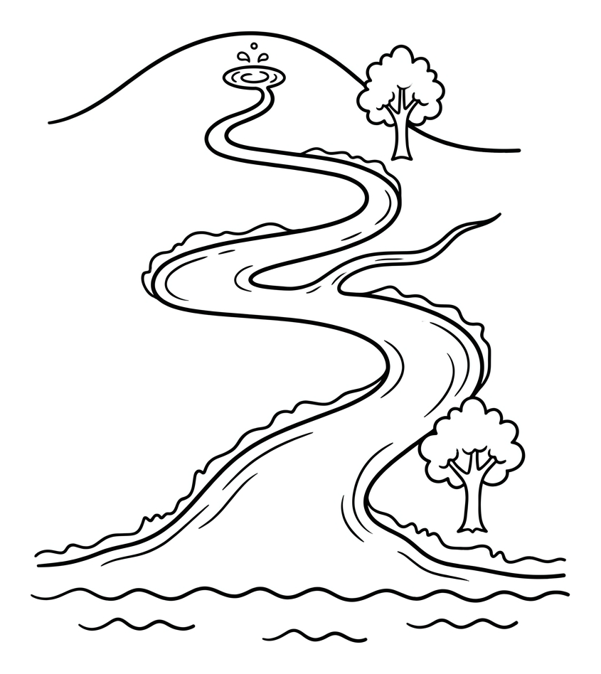
Label the parts of the river
Read each description and write the matching word on the line. Use the word bank to help you.
The place high on the hill where the river begins.
A smaller stream that joins the main river.
A bend or loop in the river as it winds across the land.
The place where the river widens and flows into the sea.
Colour the river journey
Colour the picture, then check your labels are in the right places.
- Colour the river and the sea blue.
- Colour the hills and the grassy banks green.
- Colour the trees beside the river.
Answer key
- The place high on the hill where the river begins. — source
- A smaller stream that joins the main river. — tributary
- A bend or loop in the river as it winds across the land. — meander
- The place where the river widens and flows into the sea. — mouth
What children learn from this worksheet
A river changes a great deal along its course, and this sheet helps children see the whole journey at once. They learn that a river begins at its source, often a spring high up on a hill or mountain. As it travels downhill it is sometimes joined by smaller streams called tributaries. Across flatter ground it bends from side to side in loops called meanders. Finally it reaches its mouth, where it flows into the sea, a lake or a larger river. Matching each word to the correct part builds both geographical vocabulary and an understanding of how water moves across the landscape.
How to use this sheet at home or in class
Print the worksheet at 100% scale (avoid 'fit to page', which can shrink the labelling lines). Begin by talking through the picture together and tracing the river's path with a finger from the top of the hill down to the sea. Encourage the child to read each description aloud and find the matching word in the word bank before writing it on the line. Once the labels are complete, colouring the water blue, the hills green and the sea a deeper blue helps fix the different sections in memory. For an extra challenge, ask the child to explain in their own words why a river gets wider as it nears the mouth.
Linking it to the wider curriculum
This activity sits within the Key Stage 2 unit on physical geography and rivers. It pairs well with fieldwork or a local case study, such as following a nearby stream or looking at a familiar river on a map. Teachers can extend it by introducing related vocabulary, including the riverbank, the channel and the flood plain, or by linking it to the water cycle in Science. Used as a starting point, the sheet gives children a shared diagram to refer back to as they study erosion, deposition and how people use rivers.
Common misconceptions to watch for
Children often assume rivers run from south to north, or that they always start at the sea, so it is worth emphasising that water flows downhill from a high source to a lower mouth. Another frequent mix-up is confusing a tributary (a stream joining the main river) with the mouth (where the river leaves to join the sea). The single, continuous drawing on this sheet is designed to make that distinction clear, because the whole journey is visible in one place rather than as separate pictures.
Frequently asked questions
What are the main parts of a river for KS2?
For Key Stage 2, the key parts are the source (where the river begins, usually high ground), tributaries (smaller streams that join it), meanders (the bends in its course) and the mouth (where it flows into the sea, a lake or a larger river). This worksheet covers all four.
Is this river worksheet free to print?
Yes. The worksheet is completely free to download and print for home or classroom use. It is designed to fit onto a single A4 page so you only need one sheet of paper per child.
What age group is this worksheet for?
It is aimed at children aged 7 to 9, which covers Years 3 and 4 in Lower Key Stage 2. Confident younger readers and older children revisiting the topic can also use it.
What is the difference between the source and the mouth of a river?
The source is where a river starts, often a spring high in the hills or mountains. The mouth is where it ends, flowing out into the sea, a lake or a larger river. The river travels downhill all the way from the source to the mouth.
How does this worksheet support the National Curriculum?
It supports the KS2 Geography requirement to describe and understand key aspects of physical geography, including rivers, and helps children build the geographical vocabulary used to describe a river's features.
Curriculum links
- KS2 Geography, Human and physical geography: describe and understand key aspects of physical geography, including rivers and the water cycle.
- KS2 Geography, Geographical skills and fieldwork: use the eight points of a compass and basic geographical vocabulary to describe features such as a river, source and mouth.
- KS2 Geography, Locational knowledge: name and locate geographical regions and their identifying physical characteristics, including rivers.
Made by The Owee education team. Updated 02/06/2026. Free to print and share.
More learning, made playful
Owee turns topics like this into age-right quizzes for children aged 5 to 10, with a treehouse that grows as they learn. Three subjects are free, forever.
Get Owee free