Geography · Map-reading and colouring worksheet
Reading a Map: Symbols and a Key — Free KS2 Geography Worksheet
Maps are a kind of code, and the key (sometimes called the legend) is what cracks it. Real Ordnance Survey maps pack a huge amount of information into small symbols, so being able to match a symbol to its meaning is one of the most useful map-reading skills a child can build in Key Stage 2.
This free, printable worksheet uses a friendly bird's-eye picture of a countryside area. Children identify what each symbol stands for using the supplied word bank, then colour the map features. It works well as a starter activity, a quick assessment, or a calming task to finish a geography lesson.

Reading a Map: Symbols and a Key
Free Geography worksheet · Ages 9 to 11
Crack the map code
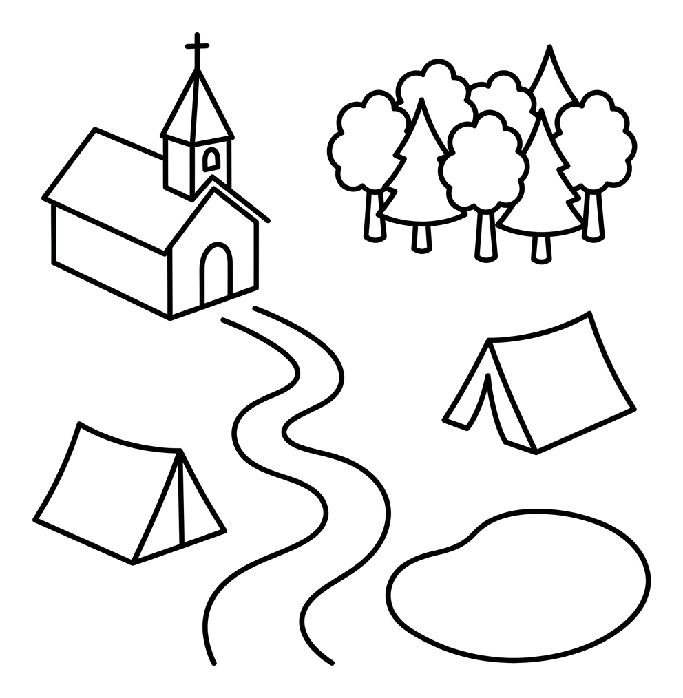
Look at each symbol on the map. Use the word bank to write what each one stands for on the line.
A small building with a cross on top stands for a place of worship. What is it?
A rounded patch of several trees together stands for an area of trees. What is it?
A thin winding line you can walk along stands for a path with no cars. What is it?
A triangle shaped like a tent stands for a place where you can put up tents and stay. What is it?
The rounded shape of water with a curved edge stands for a small body of still water. What is it?
Colour the map sensibly
Colour the map features using sensible map colours, like a real mapmaker would.
- Colour the wood (the patch of trees) green.
- Colour the pond blue.
- Colour the footpath a dotted line in brown or orange.
- Colour the church roof and the campsite tent any bright colour you like.
Answer key
- A small building with a cross on top stands for a place of worship. What is it? — church
- A rounded patch of several trees together stands for an area of trees. What is it? — wood
- A thin winding line you can walk along stands for a path with no cars. What is it? — footpath
- A triangle shaped like a tent stands for a place where you can put up tents and stay. What is it? — campsite
- The rounded shape of water with a curved edge stands for a small body of still water. What is it? — pond
- Colour the wood (the patch of trees) green. — green
- Colour the pond blue. — blue
- Colour the footpath a dotted line in brown or orange. — brown or orange
- Colour the church roof and the campsite tent any bright colour you like. — any
What this worksheet teaches
The worksheet focuses on a single, transferable idea: maps use simplified symbols to represent real places and features, and a key tells you what each one means. Children practise reading a small map drawn from above (a bird's-eye view), matching everyday symbols such as a church, a wood, a footpath and a campsite to the right words. This is the same skill they will use on genuine Ordnance Survey maps, where a tent means a campsite and a cross often marks a place of worship. Working from a picture first, before tackling a real OS map, lowers the cognitive load and lets children concentrate on the symbol-to-meaning link.
Why map symbols matter in KS2 geography
By Years 5 and 6, children are expected to use maps, atlases, globes and digital mapping confidently, and to interpret symbols and a key as part of the geographical skills strand of the National Curriculum. Symbols are efficient: a single icon can stand for a feature that would be impossible to draw to scale. Learning to decode them supports wider topics too, from local fieldwork and route planning to understanding land use, settlement and the human and physical geography of the United Kingdom. The colouring element also reinforces the idea that different feature types (woodland, water, paths) are often shown in consistent ways.
How to use it at home or in class
Print one copy per child on A4. Start by talking about any maps the child already knows, perhaps a theme-park map, a bus map or a walking map. Read through the word bank together so the vocabulary is familiar, then let the child work out which symbol matches which description and write the answer on the lines. Encourage them to justify their thinking aloud ("a tent must mean somewhere to camp"). Finish with the colouring task, which is a natural way to talk about why mapmakers use sensible colours, such as green for woodland and blue for water. For an extension, ask the child to invent and draw a symbol of their own and add it to a key.
Extending the learning
Once children are comfortable with this picture map, move them on to a simplified Ordnance Survey extract and challenge them to spot the same features in the real key. You could plan a short local walk and ask them to predict the symbols they will pass, then check on a printed or digital OS map afterwards. Pairing the worksheet with a compass-direction or grid-reference activity builds towards full fieldwork. The aim across KS2 is for children to move from reading a friendly picture map to confidently interpreting standard maps of the UK and the wider world.
Frequently asked questions
What is a map key and why do maps use symbols?
A map key, sometimes called a legend, is a small list that explains what each symbol on a map means. Maps use symbols because they are a quick, space-saving way to show real features, such as a tent for a campsite or a cross for a church, without having to draw everything in detail or to scale.
Which key stage and age is this worksheet for?
It is designed for KS2 children in Years 5 and 6, roughly ages 9 to 11. The vocabulary and the bird's-eye map style suit upper Key Stage 2, but confident Year 4 children may also enjoy it as a stretch activity.
Do children need a real Ordnance Survey map to complete it?
No. The worksheet is fully self-contained: the map picture and a word bank are printed on the page. It is, however, an excellent stepping stone to reading genuine Ordnance Survey maps afterwards, because it uses the same idea of matching symbols to meanings.
Is this worksheet really free to print?
Yes. The worksheet is free to download and print for home or classroom use. It fits on a single A4 page, so one print per child is all you need.
How does this link to the National Curriculum?
It supports the KS2 geography requirement to use symbols and a key, including Ordnance Survey maps, to build knowledge of the UK and the wider world. It also reinforces the broader skill of using maps and atlases to locate and describe features.
Curriculum links
- KS2 Geography, Geographical skills and fieldwork: use maps, atlases, globes and digital/computer mapping to locate countries and describe features studied.
- KS2 Geography, Geographical skills and fieldwork: use symbols and a key (including the use of Ordnance Survey maps) to build their knowledge of the United Kingdom and the wider world.
- KS2 Geography, Geographical skills and fieldwork: use the eight points of a compass, four- and six-figure grid references, symbols and key (a related skill this worksheet helps prepare children for).
- KS2 Geography, Place and locational knowledge: name and locate features and describe how aspects of human and physical geography are represented on maps.
Made by The Owee education team. Updated 02/06/2026. Free to print and share.
More learning, made playful
Owee turns topics like this into age-right quizzes for children aged 5 to 10, with a treehouse that grows as they learn. Three subjects are free, forever.
Get Owee free