Geography · Colouring and matching worksheet
Map Symbols and a Key: Free KS1 Geography Worksheet
This free, printable worksheet introduces children aged 6 to 7 to map symbols and the idea of a key. Maps use small pictures, called symbols, to stand for real things such as a tree, a house, a church, a river, a road or a school. A key is the little box that explains what each symbol means, so anyone can read the map. Children colour six common symbols, then use the word bank to write what each one stands for.
It is completely free to print, use and share, at home or in the classroom. Just hit print, or save it as a PDF.

Map Symbols and a Key
Free Geography worksheet · Ages 6 to 7
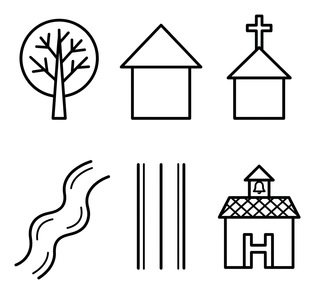
Colour the map symbols
Colour each of the six map symbols. You could use the colours a real map maker might choose, such as green for the tree, blue for the river and grey for the road.
- Colour the tree, house, church, river, road and school.
Match each symbol to its meaning
Look at each map symbol. Write what it stands for on the line. Use the word bank to help you.
A leafy plant that grows tall, often shown in a park or wood
A building where a family lives
A building with a cross on top where people go to worship
A wavy line of water that flows across the land
A long, straight way that cars and buses travel along
A building where children go to learn
Answer key
- A leafy plant that grows tall, often shown in a park or wood — tree
- A building where a family lives — house
- A building with a cross on top where people go to worship — church
- A wavy line of water that flows across the land — river
- A long, straight way that cars and buses travel along — road
- A building where children go to learn — school
What is on the worksheet
Six clear, friendly map symbols are laid out in a tidy grid: a tree, a house, a small church with a cross, a wavy river, a straight road and a school building. These are drawn in a simple plan view, the bird's-eye style used on real maps, with bold, even outlines that are comfortable for small hands to colour.
Below the picture there is a colouring task and a matching task. A word bank lists the six things the symbols stand for, and there are write-on lines so children can record their answers. The aim is not to draw a perfect map, but to grasp the big idea: a symbol is a small picture that stands for something real, and a key tells you what it means.
How to use it at home or in the classroom
Print the worksheet, or open it on a tablet and print from there. Start with the colouring, which is a relaxed way in: you might suggest green for the tree, blue for the river and grey for the road, just as a map maker might choose.
Then work through the matching task together. Point to each symbol and ask what it reminds your child of, then help them find the right word in the word bank and write it on the line. Talk about why a map maker would use a cross for a church or a wavy line for a river. In class it works well as a starter before reading a simple local map, or before a walk around the school grounds to spot real versions of the symbols.
What your child will learn
By the end of the activity, your child should understand that maps use symbols, small pictures that stand for real features, and that a key is the box that explains what each symbol means. They will be able to recognise six common symbols: a tree, a house, a church, a river, a road and a school.
This is an important early map skill. Once a child knows that one small picture can stand for something much bigger in the real world, they can begin to read simple maps, plans and atlases. It also builds the vocabulary, symbol and key, that they will meet again throughout primary geography.
A note for teachers
This worksheet supports the Key Stage 1 geography programme of study for geographical skills and fieldwork, specifically using basic symbols in a key when devising or reading a simple map. It pairs well with a class map of the local area, a simple plan of the classroom or playground, or a short fieldwork walk to spot the real features the symbols represent.
A point worth sharing with pupils: real maps, such as those from the Ordnance Survey, use a standard set of symbols, so the exact symbol can vary from map to map. What matters at this stage is the underlying idea, that symbols stand for real things and a key explains them. There is no log-in, no watermark and no catch, so you are welcome to print copies for your class and to link to this page from your school website or newsletter.
Frequently asked questions
What is a map symbol?
A map symbol is a small picture or sign that stands for something real on a map, such as a tree, a church or a road. Symbols let a map show a lot of information in a small space, without writing out every word.
What is a key on a map?
A key, sometimes called a legend, is a small box on a map that lists the symbols and explains what each one means. You read the key first, then you can understand the symbols on the map. This worksheet helps children learn that idea.
What age or year group is this worksheet for?
It is designed for children aged 6 to 7, which is Year 2 (Key Stage 1) in England. Confident Year 1 children and older children revising map skills will also find it useful.
Are these the real Ordnance Survey map symbols?
These are simple, child-friendly versions of common map symbols rather than exact Ordnance Survey symbols. At Key Stage 1 the goal is to understand that symbols stand for real features and that a key explains them. Real maps use a standard set of symbols that children meet in more detail later.
Is this map symbols worksheet free to print and share?
Yes. It is completely free to print, use at home or in class, and share. There is no sign-up and no watermark, and you are welcome to link to this page from a school website or newsletter.
Curriculum links
- KS1 Geography Geographical skills and fieldwork (statutory): 'use simple compass directions... and locational and directional language... to describe the location of features and routes on a map'
- KS1 Geography Geographical skills and fieldwork (statutory): 'devise a simple map; and use and construct basic symbols in a key'
- KS1 Geography Geographical skills and fieldwork (statutory): 'use aerial photographs and plan perspectives to recognise landmarks and basic human and physical features'
Made by The Owee education team. Updated 02/06/2026. Free to print and share.
More learning, made playful
Owee turns topics like this into age-right quizzes for children aged 5 to 10, with a treehouse that grows as they learn. Three subjects are free, forever.
Get Owee free