Geography · Colouring and short-answer worksheet
Hot and Cold Places of the World: Free KS1 Geography Worksheet
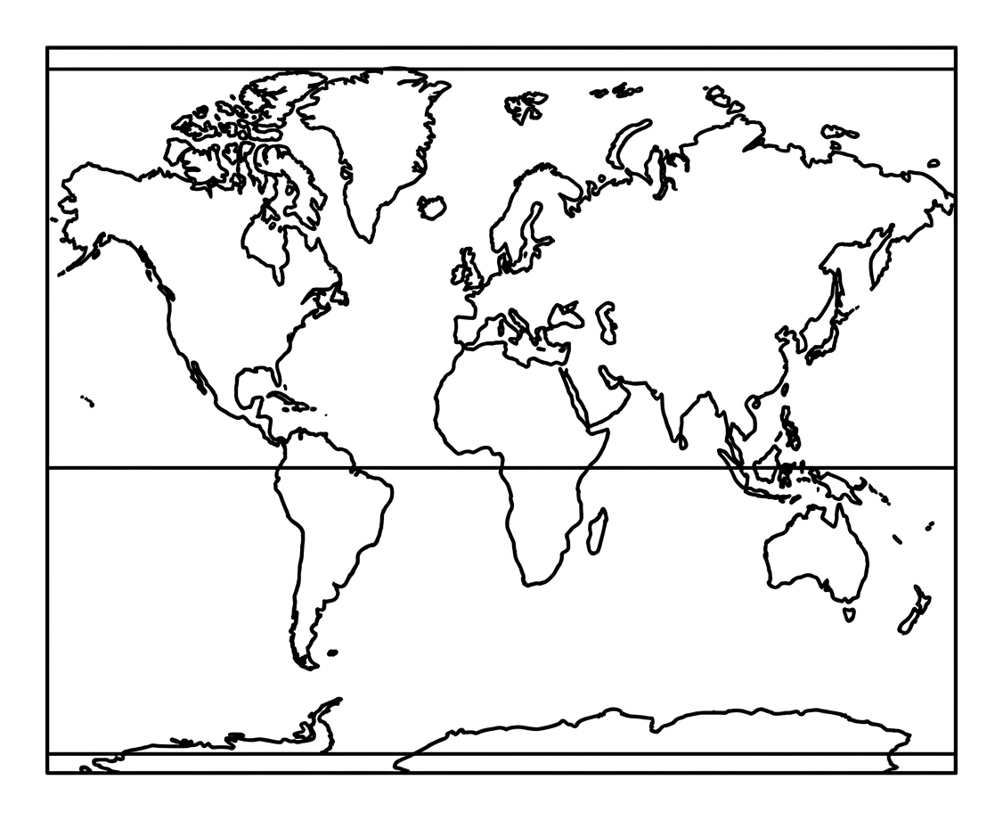
This free printable worksheet helps children in Years 1 and 2 begin to understand how temperature changes across the world. By colouring a simple map, they learn that the hottest places sit near the Equator in the middle of the map, while the coldest places sit at the North and South Poles at the very top and bottom.
It supports the KS1 geography curriculum and works well as a classroom starter, a homework task, or a quiet activity at home. Everything fits on a single A4 page, ready to print and colour.

Hot and Cold Places of the World
Free Geography worksheet · Ages 6 to 7
Activity 1
Colour the world map to show where it is hot and where it is cold. Use a warm colour (red, orange or yellow) for the middle band near the Equator. Use a cool colour (blue or pale grey) for the bands at the top and bottom near the North and South Poles.
- Colour the middle band near the Equator in a warm colour.
- Colour the top and bottom bands near the Poles in a cool colour.
Activity 2
Use the word bank to help you finish the sentences about hot and cold places.
The line across the middle of the map is called the ____.
Places near the Equator are very ____.
The North Pole and South Pole are at the top and bottom of the world.
Places near the North and South Poles are very ____.
Answer key
- The line across the middle of the map is called the ____. — Equator
- Places near the Equator are very ____. — hot
- The North Pole and South Pole are at the top and bottom of the world. — Poles
- Places near the North and South Poles are very ____. — cold
What this worksheet teaches
Young children are naturally curious about why some countries are scorching hot and others are covered in snow. This worksheet introduces the simple idea that a place's temperature is closely linked to where it sits on the planet. The Equator is an imaginary line around the middle of the Earth, and the land and sea closest to it receive the most direct sunlight, making these areas the hottest. The North Pole and South Pole sit at the very top and bottom of the world, where sunlight arrives at a shallow angle and the regions stay frozen for much of the year. Colouring the map gives children a clear visual memory of this pattern: warm colours in the middle, cool colours at the edges.
How to use the worksheet
Print the sheet on plain A4 paper. Begin by talking through the picture together, pointing out the bold line across the middle (the Equator) and the bands at the top and bottom (the polar regions). Encourage the child to colour the middle band of the map in a warm colour such as red, orange or yellow, and the top and bottom bands in a cool colour such as blue or pale grey. Once the map is coloured, the short written questions check that they can name where the hottest and coldest places are. There are no right or wrong colours so long as warm and cool tones are matched to the correct areas, so the task stays low-pressure and confidence-building.
Linking to the KS1 geography curriculum
The activity is designed to match the human and physical geography strand of the Key Stage 1 programme of study, which asks pupils to identify the location of hot and cold areas of the world in relation to the Equator and the North and South Poles. It also reinforces wider KS1 vocabulary and map skills, helping children become familiar with continents shown as simple shapes and with directional ideas such as top, bottom and middle. Used alongside a globe or a wall map, it gives teachers a quick, evidence-friendly way to introduce or revisit this objective.
Ideas to extend the learning
After completing the sheet, you could ask the child to think of animals that live in hot places (such as camels or lions) and cold places (such as penguins or polar bears), helping them connect climate to living things. You might also look at family photographs from holidays, or point out hot and cold countries on a globe, asking whether each one is near the middle or near the top and bottom. For a creative follow-up, children can draw the clothes they would pack for a very hot place and a very cold place, building everyday understanding of how climate affects daily life.
Frequently asked questions
What are the hottest places on Earth?
The hottest areas of the world are found near the Equator, the imaginary line around the middle of the planet. These regions receive the most direct sunlight throughout the year, which keeps temperatures high. On this worksheet, children colour the middle band of the map in a warm colour to show this.
Why are the North and South Poles so cold?
The North and South Poles sit at the very top and bottom of the Earth, where sunlight arrives at a low, shallow angle and the warmth is spread thinly. Much of the polar regions stays frozen all year. On the worksheet, these areas are coloured in a cool colour such as blue.
Is this worksheet suitable for Year 1 and Year 2?
Yes. It is designed for children aged 6 to 7 in Key Stage 1 and matches the curriculum objective on hot and cold areas of the world. The map uses simple continent shapes and clear bands, so it is accessible for early geographers while still introducing real vocabulary.
Do I need a globe or atlas to use this sheet?
No, the worksheet works on its own, but pairing it with a globe, atlas or wall map adds depth. Showing the same Equator line and poles on a globe helps children connect the flat map to the round Earth.
Is the worksheet really free to print?
Yes. The printable is completely free to download and print at home or in the classroom. It fits on a single A4 page and needs no special paper or equipment, just colouring pencils or crayons.
Curriculum links
- KS1 Geography (Human and physical geography): identify the location of hot and cold areas of the world in relation to the Equator and the North and South Poles.
- KS1 Geography (Geographical skills and fieldwork): use world maps, atlases and globes to identify continents and oceans.
- KS1 Geography (Human and physical geography): use basic geographical vocabulary to refer to physical features.
- KS1 Geography (Locational knowledge): name and locate the world's seven continents and five oceans.
Made by The Owee education team. Updated 02/06/2026. Free to print and share.
More learning, made playful
Owee turns topics like this into age-right quizzes for children aged 5 to 10, with a treehouse that grows as they learn. Three subjects are free, forever.
Get Owee free