Geography · Colouring and labelling worksheet
The Equator and the Hemispheres: Free KS2 Geography Worksheet
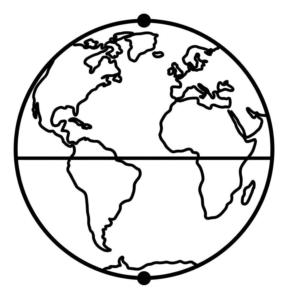
This free printable worksheet introduces children aged 7 to 9 to one of the most important ideas in Key Stage 2 geography: how we describe where places are on the globe. Using a single hand-drawable globe, children colour the land and sea, then identify the Equator, the Northern and Southern Hemispheres and the North and South Poles.
It works equally well at home or in the classroom, needs nothing more than colouring pencils, and prints to a single A4 page. A word bank is included so children can succeed independently, and short questions check understanding without overwhelming early learners.

The Equator and the Hemispheres
Free Geography worksheet · Ages 7 to 9
Activity 1
Colour the globe. Use blue for the oceans (sea) and green or brown for the land. Then go over the bold line around the middle of the globe in red, because this is the Equator.
- Colour the oceans (the sea) blue.
- Colour the land green or brown.
- Colour the line around the middle of the globe red. This is the Equator.
Activity 2
Use the word bank to fill in the missing word for each sentence. Write your answer on the line.
The imaginary line around the middle of the Earth is called the __________.
The half of the Earth above the Equator is the __________.
The half of the Earth below the Equator is the __________.
The point at the very top of the globe is the __________.
The point at the very bottom of the globe is the __________.
Answer key
- The imaginary line around the middle of the Earth is called the __________. — Equator
- The half of the Earth above the Equator is the __________. — Northern Hemisphere
- The half of the Earth below the Equator is the __________. — Southern Hemisphere
- The point at the very top of the globe is the __________. — North Pole
- The point at the very bottom of the globe is the __________. — South Pole
What this worksheet teaches
This sheet helps children build the vocabulary of locational knowledge: the Equator, the two hemispheres and the poles. The Equator is an imaginary line drawn around the middle of the Earth at 0° latitude. It divides the planet into two equal halves, or hemispheres. Everything above the Equator is in the Northern Hemisphere and everything below it is in the Southern Hemisphere. The United Kingdom, for example, lies in the Northern Hemisphere. The North Pole sits at the very top of the globe and the South Pole at the very bottom; these are the two points furthest from the Equator. By colouring and labelling a single globe, children fix these terms in place visually before moving on to latitude, longitude and the tropics later in Key Stage 2.
How to use it at home or in class
Begin by talking about the globe as a whole: where is the land, where is the sea? Encourage the child to colour the oceans blue and the land green or brown so the continents stand out clearly. Next, trace the bold line around the middle with a finger and explain that this is the Equator. Ask which half is the top (Northern Hemisphere) and which is the bottom (Southern Hemisphere). Finally, point to the two markers at the top and bottom and name the North and South Poles. The word bank at the foot of the page means children can attempt the writing tasks confidently, and you can discuss any answers together afterwards rather than treating it as a test.
Why the Equator and hemispheres matter
These ideas are not just labels; they help explain the world children see around them. Places near the Equator are generally hot all year round because the Sun's rays are most direct there, while the poles are extremely cold. The hemispheres also help explain why the seasons are reversed: when it is summer in the Northern Hemisphere it is winter in the Southern Hemisphere. Understanding that the Earth can be divided in this way gives children a framework they will return to when they study climate zones, time zones, the Tropics of Cancer and Capricorn, and the Arctic and Antarctic Circles in later years.
Extending the learning
Once the worksheet is complete, you can deepen understanding with a real globe or a world map. Ask the child to find their own country and decide which hemisphere it is in, then choose a country in the opposite hemisphere to compare. You might also point out countries the Equator passes through, such as Ecuador, Kenya and Indonesia, and discuss what their weather might be like. For a quick game, name a place and ask whether it is north or south of the Equator. These follow-up activities turn the printable into a springboard for wider discussion about our planet.
Frequently asked questions
What is the Equator in simple terms for KS2?
The Equator is an imaginary line drawn around the middle of the Earth, halfway between the North and South Poles. It divides the planet into two equal halves called hemispheres and marks the line of 0 degrees latitude. Places near the Equator tend to be hot all year round.
What are the Northern and Southern Hemispheres?
A hemisphere means half of a sphere, or half of the Earth. The Equator splits the globe into two: everything above the Equator is the Northern Hemisphere and everything below it is the Southern Hemisphere. The United Kingdom is in the Northern Hemisphere.
Which hemisphere is the United Kingdom in?
The United Kingdom is in the Northern Hemisphere because it lies well above the Equator. It is also part of the continent of Europe. This worksheet helps children locate the hemispheres so they can begin placing their own country on the globe.
Is this Equator and hemispheres worksheet free to print?
Yes. This worksheet is completely free to download and print at home or in school. It fits on a single A4 page and needs only colouring pencils, making it ideal for Year 3 and Year 4 geography lessons or home learning.
What age and key stage is this worksheet for?
It is designed for children aged 7 to 9, which covers Years 3 and 4 at Key Stage 2. The activities and word bank are pitched to introduce the Equator, hemispheres and poles in an accessible, colour-and-label format.
Curriculum links
- KS2 Geography, Locational knowledge: identify the position and significance of latitude, longitude, Equator, Northern Hemisphere, Southern Hemisphere, the Tropics of Cancer and Capricorn, Arctic and Antarctic Circle.
- KS2 Geography, Locational knowledge: name and locate the world's seven continents and five oceans (supporting context for the globe).
- KS2 Geography, Geographical skills and fieldwork: use maps, atlases, globes and digital mapping to locate countries and describe features studied.
- KS2 Geography, Place knowledge: understand geographical similarities and differences through the study of regions, including how location affects climate.
Made by The Owee education team. Updated 02/06/2026. Free to print and share.
More learning, made playful
Owee turns topics like this into age-right quizzes for children aged 5 to 10, with a treehouse that grows as they learn. Three subjects are free, forever.
Get Owee free