Geography · Colouring and labelling worksheet
The 7 Continents and 5 Oceans: Free KS1 Geography Worksheet
This free, printable continents and oceans worksheet helps children aged 5 to 7 begin to name and locate the world's seven continents and five oceans on a simple world map. Children colour each continent a different colour, then write the names of the continents and oceans using the word bank.
It is completely free to print, use and share, at home or in the classroom. Just press print, or save it as a PDF.

The 7 Continents and 5 Oceans
Free Geography worksheet · Ages 5 to 7
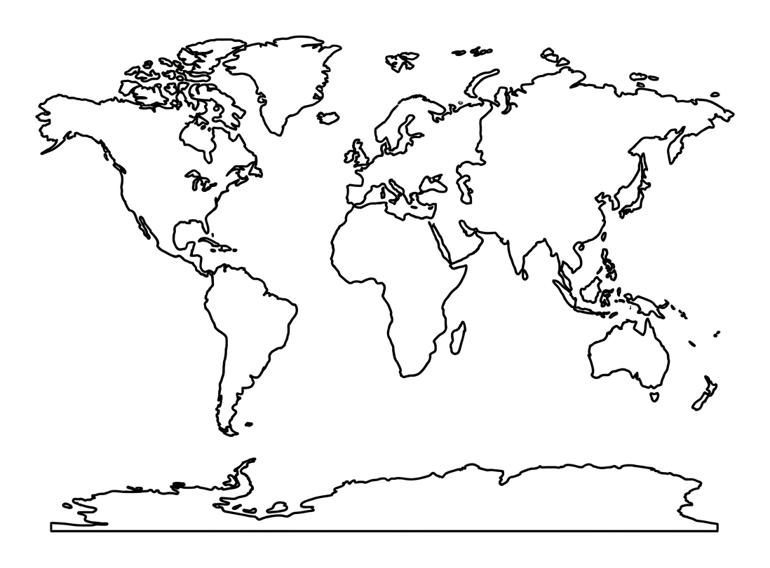
Colour the world map
Colour each of the seven continents a different colour so you can tell them apart. You can colour the oceans blue if you like.
- Colour all of the oceans (the spaces around the land) light blue.
- Colour the biggest continent green.
- Colour the smallest continent, near the bottom, white or pale grey.
Name the continents and oceans
Look at your map. Write the names of the seven continents and the five oceans on the lines, using the word bank to help you.
Which continent is the largest?
Which continent is the coldest and found at the very bottom of the map?
Which continent do we live on in the United Kingdom?
Which is the largest ocean?
Which ocean is found at the very top of the map, around the North Pole?
Answer key
- Which continent is the largest? — Asia
- Which continent is the coldest and found at the very bottom of the map? — Antarctica
- Which continent do we live on in the United Kingdom? — Europe
- Which is the largest ocean? — Pacific Ocean
- Which ocean is found at the very top of the map, around the North Pole? — Arctic Ocean
What is on the worksheet
One clear, friendly line drawing of a flat world map, with the seven continents shown as separate, well-spaced shapes and the oceans left blank around them. There is a word bank of the seven continents and five oceans to support early readers, and a set of lines to write the names on.
The map has bold, even outlines and plenty of white space, so it is comfortable for small hands to colour and looks lovely on display afterwards. Country borders are deliberately left off so the picture stays simple and the focus is on the continents themselves.
How to use it at home or in the classroom
Print the worksheet, or open it on a tablet and print from there. First, let your child colour each continent a different colour, this makes the seven separate landmasses easy to see and is a relaxed way in.
Then look at the map together. Help your child point to each continent and each ocean, then write the names on the lines using the word bank to help. For younger children, you can read the word bank aloud and let them match the words by sound and shape. A globe or a class map nearby makes a great point of comparison. In school it works well as a starter for a topic on the wider world, or as a quick check of locational knowledge.
What your child will learn
By the end of the activity, your child should be able to name the seven continents (Africa, Antarctica, Asia, Europe, North America, Oceania and South America) and the five oceans (the Arctic, Atlantic, Indian, Pacific and Southern Oceans), and begin to locate them on a world map.
Naming and locating the continents and oceans is one of the first steps in primary geography. It gives children a mental map of the wider world and a foundation for later learning about countries, climates and how places connect.
A note for teachers
This worksheet supports the Key Stage 1 geography programme of study for locational knowledge, where pupils name and locate the world's seven continents and five oceans. It works as a quick assessment of whether pupils can identify each continent and ocean, and pairs well with a globe, an atlas or an interactive world map.
Please note that the names Oceania (used here to include Australasia) and the Southern Ocean are the modern conventions; you may prefer 'Australia' or 'Australasia' and four oceans depending on your scheme of work, so adapt the word bank to match. There is no log-in, no watermark and no catch. You are welcome to print copies for your class and to link to this page from your school website or newsletter.
Frequently asked questions
What are the 7 continents and 5 oceans for KS1?
The seven continents are Africa, Antarctica, Asia, Europe, North America, Oceania (sometimes called Australia or Australasia) and South America. The five oceans are the Arctic, Atlantic, Indian, Pacific and Southern Oceans. The Pacific is the largest ocean and Asia is the largest continent.
What age or year group is this worksheet for?
It is designed for children aged 5 to 7, which is Years 1 and 2 (Key Stage 1) in England. Older children revising the continents and oceans, and confident younger children who enjoy colouring, will get something from it too.
Is this continents and oceans worksheet free to print and share?
Yes. It is completely free to print, use at home or in class, and share. There is no sign-up and no watermark. You are welcome to link to this page from a school website or newsletter.
How do I print or save the worksheet?
Press the Print button on this page, or use your browser's print option. To keep a copy, choose 'Save as PDF' as the destination in the print dialog. The worksheet is designed to fit a single A4 page.
Why does this worksheet say Oceania and five oceans?
Modern geography commonly uses 'Oceania' for the continent that includes Australia, New Zealand and the Pacific islands, and counts five oceans by recognising the Southern Ocean around Antarctica. Some schemes still teach 'Australia' or 'Australasia' and four oceans, so simply adapt the word bank to match the version your child is learning.
Curriculum links
- KS1 Geography Locational knowledge (statutory): 'name and locate the world's seven continents and five oceans'
- KS1 Geography Geographical skills and fieldwork (statutory): 'use world maps, atlases and globes to identify the United Kingdom and its countries, as well as the countries, continents and oceans studied at this key stage'
- KS1 Geography Geographical skills and fieldwork (statutory): 'use simple compass directions and locational and directional language to describe the location of features and routes on a map'
Made by The Owee education team. Updated 02/06/2026. Free to print and share.
More learning, made playful
Owee turns topics like this into age-right quizzes for children aged 5 to 10, with a treehouse that grows as they learn. Three subjects are free, forever.
Get Owee free